First results from high density outdoor air quality mapping
The Ulisses project has developed a set of carbon dioxide loggers equipped with GPS. The purpose is to already now explore the potential of future systems, and to prepare for the big data challenges we will experience with real-time air quality data.
A route in Stockholm was covered by car once an hour for 24 hours generating 5 000 unique data points. Each data point carry information about the local air quality at a specific time and location. The amount of data is sufficient for proper statistical analysis in order to extract relevant air quality parameters down to street level.
A route in Stockholm was covered by car once an hour for 24 hours generating 5 000 unique data points. Each data point carry information about the local air quality at a specific time and location. The amount of data is sufficient for proper statistical analysis in order to extract relevant air quality parameters down to street level.
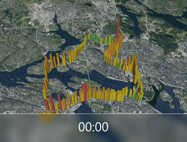
5,000 data points acquired in Stockholm during 24 hours on 15 and 16 May 2019.

A ULISSES member, Stephan Schröder, volunteered to map 42 km of air quality in Stockholm during Stockholm Marathon on 1 June 2019. At the upper left, the high levels are caused by the dense crowd of people starting the race at the same time. The high levels at Södermalm are caused by limited ventilation in the tunnel. The “green” sections are located within areas either with good ventilation or low traffic.
The measured carbon dioxide elevation is caused by combustion and thus a tracer for the amount of exhaust gas pollution present in the urban air. This data is relevant also for our health since it correlates to unhealthy substances such as nitrogen oxides, ozone, carbon monoxide and black carbon. After this first test we have an even stronger confidence that the ULISSES technology in the future will provide real-time air quality data, for everyone, everywhere.
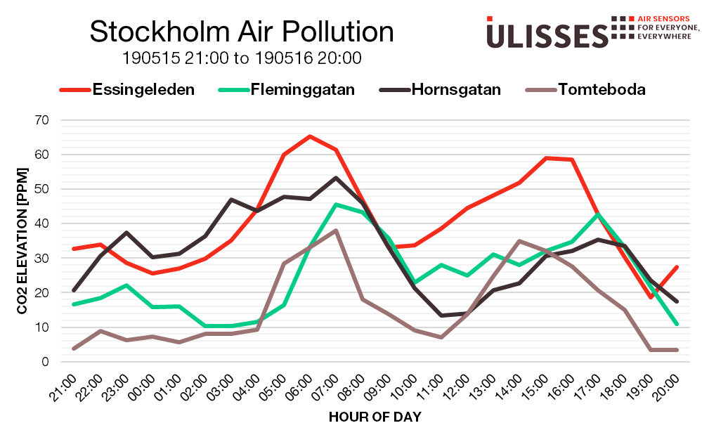
Daily variation of carbon dioxide at four selected streets extracted from the 24 hour test.
Essingeleden – Highway with dense traffic.
Fleminggatan – Large street at the city center of Stockholm, Kungsholmen.
Hornsgatan – Considered as one of the most polluted Streets in Stockholm, Södermalm.
Tomteboda – Part of highway connecting to Essingeleden with a high location and more windy conditions.
 This project has received funding from the European Union’s Horizon 2020 research and innovation programme under grant agreement No 825272 (ULISSES).